
Visit our UNESCO World Heritage Sites in Wales
Find out how to make the most of your visit to each of the four UNESCO World Heritage Sites in Wales.

Instagram-friendly Welsh landmarks
Take a look at these ten must-see Instagrammable coastal landmarks for you and your camera.
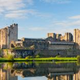
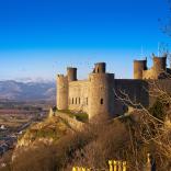
Is Wales the castle capital of Europe?
With over 400 castles, wherever you go on holiday in Wales, you won't be too far from one to visit.

A Royal Mint experience
Discover the history of coins and how they are made at the Royal Mint Experience in Llantrisant.